This week in our Digital History class, we were asked to comment on how historians can use new technologies to disseminate our sources. In order to do so, we were also asked to talk about our sources and incorporating them into a new, digital history.
So what are my sources and what do they have to do with digital history? Good question! For my research, I’ve used a fairly wide range of sources including, but not limited to, war diaries, memos, correspondence, police reports, newspaper articles, photographs, interviews, maps, aerial photographs, satellite imagery, physical objects, and the landscape. With few exceptions, very few of my sources were digital but, starting with the digitization of microfilm records, nearly all of my sources are now in a digital format.
For how I’ve used these sources, I wanted to provide an example of some of my research. As I mentioned in my last post, one of my interests is mapping PoW camps in Canada. Among the many difficulties in doing so is that I have yet to come across detailed maps showing the location and layout of the small PoW labour projects that were scattered across the country. Today, I wanted to share the various methods I attempted to fill this gap for one particular labour project in Manitoba’s Riding Mountain National Park.
The camp in question operated from October 1943 to October 1944 and housed 440 German PoWs and about 150 Canadian military and civilian personnel. Despite having been built at a cost of over $200,000, the buildings were demolished at the end of the war and all traces of the camp were removed.
Having a great interest in the history of this camp, I wanted to create a map for both my own use as well as use in my interpretive programs (see here). The first step for me was to look at what the area looks like today. Using Google’s satellite imagery as well as aerial and satellite photographs from Parks Canada, I was able to recognize some features of the former camp but nature has reclaimed most of the site in the last seventy odd years.
The clearing in the above shows the location of the former camp. Some features (like the foundation in the middle) are still visible today.
The next step was to then examine photographs of the camp to determine the approximate shape and layout of the buildings. By tracing out rooflines, I was able to get a general idea of the camp’s layout but this was made difficult by buildings in the foreground obscuring those behind.
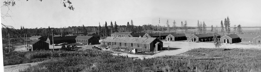
My third step was to then use the physical landscape as a primary source in determining the locations of the buildings in question. As some of the earthen berms that marked the location of the buildings still remain at the site, I was able to gain a general idea of the location, shape, and size of the buildings in question. However, in other sections of the site, contractors appeared to have bulldozed some buildings, leaving no trace of its layout.

While I had done the previous steps on my own, I began working with an archaeologist who introduced me to some new methods that helped narrow down our approach. Using an 1949 aerial photograph of the site, we were able to map the exact layouts of most of the buildings and make sense of those that were hard to see in the photographs. Combining this with a 3D survey of the site, we were finally able to determine the layout of the PoW camp at Riding Mountain.

I also wanted to say that I did this with fairly limited access to any mapping programs. The satellite imagery came from Google and apart from using Photoshop to overlay the buildings on the image, the majority of my work was looking at photographs and walking around the physical site with a GPS.

This is really cool Michael! I’m impressed with what you did with the limited sources available to you. I would never have thought to do something like this prior to starting our program. It was interesting to read about the challenges you faced in recreating the map from the photograph which hid some of the background buildings.